Devastating Effects of Sea Level Riseon O’ahu around Mid-century
by Dr. Kioni Dudley
July 2017
Below are the latest maps from the U.H. School of Ocean and Earth Science and Technology (SOEST) forecasting sea level rise in the Kaka’ako, Ala Moana, Mo’ili’ili, and Waikiki areas. Similar inundation will take place in all low-lying areas around the islands. Sea level is expected to rise 1 ft. by mid-century, and 3 ft. by 2100. Builders of hospitals, high-rises, and other buildings that are expected to stand for decades are warned to plan for the worst-case scenario, more than a 9 ft. rise by 2100.

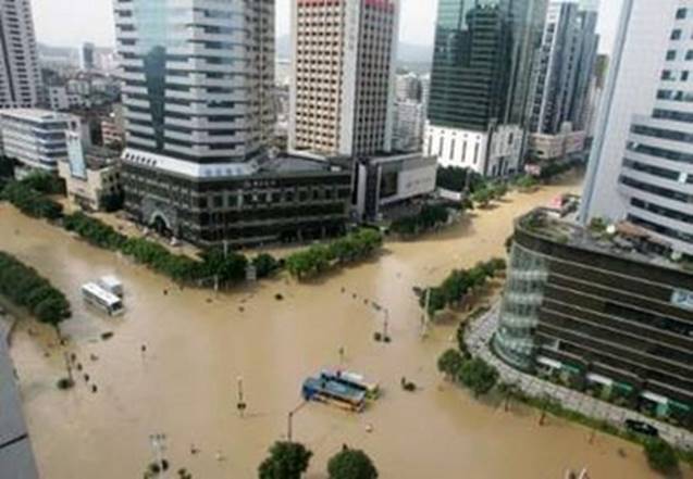
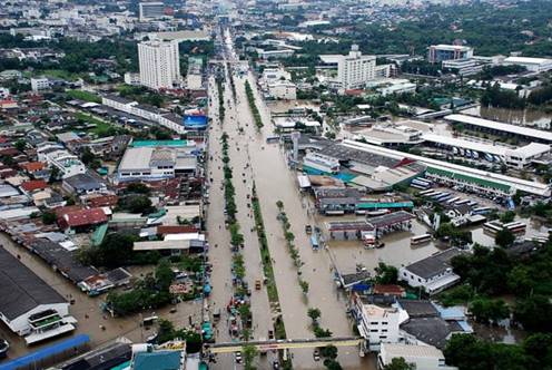
Four decades from now we can expect scenes like these.
This is what Kapiolani Blvd at Atchison will look like in mid-century, with no possibility of getting rid of the water.
Above is what Kapiolani Blvd. itself will look like in mid-century.

This is what the Ala Wai Canal and the area around it will look like.
There will be no way to get the water to recede. It will continue to rise over the decades, perhaps by as much as a foot a decade, with no end in sight for hundreds of years.
Every few weeks our city government approves another high-rise in these low-lying areas. As the seas rise over coming decades, the people of O’ahu will be stuck with hundreds of derelict high-rise apartment buildings and hotels standing deep in the swamp, darkened, empty, and poisoning the water around. Our multi-millionaires will have simply picked up and moved on from a bad investment; our beaches will be gone and tourism will be completely dead; our tax base will be decimated; our descendants will be struggling to stay alive; and we won't have the many hundreds of millions of dollars to tear down the abandoned buildings.
We need now to start preparing for the future. We need to take heed of the strong call by SOEST experts to move all future development inland. Residential high-rises need to be built in the higher valleys of Nu'uanu, Manoa, and Kalihi. None should be allowed more than a block or two below the freeway. We must expect King Street to one day become Shoreline Drive.
Those who would build in the low-lying areas must be forced to place enough money in city-held escrow accounts to pay for demolishing the buildings and cleaning the sites when the water begins to come through the surface. And developers must be forced to give notice to buyers that their buildings will have to be demolished as the water rises. The city must insure that purchasers know they buy at their own risk, and that the city cannot be sued.
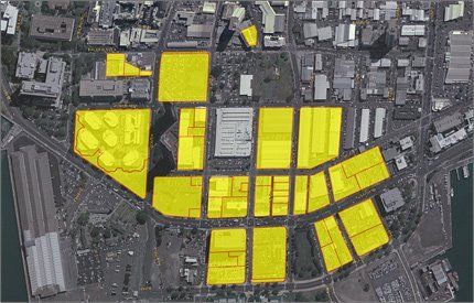
I initially wrote all of the above as an op-ed article many months ago, before I was aware that Kamehameha Schools owned large sections of Kaka’ako and Mo’ili’ili, and was in the process of redeveloping both. Below is part of the Kamehameha Schools webpage showing plans for Kaiāulu ‘o Kaka‘ako which will be built over 9 blocks between Restaurant Row and Ward Centers, mauka of Ala Moana Boulevard. It will include seven high-rise towers. This is dangerous. If KS continues building and selling apartments to people while knowing that as the water breaks through the ground, the value of these people’s investment will plummet, surely the Estate will be held accountable in the future.
The lawsuits could bankrupt the trust.
Decisions need to be made about the whole Kaka’ako to Diamond Head area before any more high-rises are built. How will we adapt to the rising seas? Because fresh water will break through the ground as the seas rise, dikes will not solve our problems. Will we bring dirt from the mountains and raise the level of the ground as the years go on? Or will we attempt to turn the area into a Venice with water between the buildings? In either case, we will need to build high-rises so that all operations can move to the second floor in the future. Or, will we tear down all of the buildings and clear the ground as the water rises, so as to have less-polluted water at our shores? If so, we must build low-rise buildings that can be torn down.